The High Peak Trail runs for around 17 miles, from Dowlow, just outside Buxton, to Cromford in the Derwent Valley. Like many such trails around the country, it follows the course of a defunct train line, in this case the Cromford and High Peak Railway, which connected the Peak Forest Canal in the north west of Derbyshire with the Cromford Canal in the middle of the county. You can see evidence of the line in the Goyt Valley as well as across the moorland above it, and the trail had been on my to-do list since I first visited that area last year.
Having walked on similar trails before, I was aware that long stretches can become somewhat routine, especially when they've been lined with bushes and trees or pass through extended railway cuttings. I decided to save this day out for winter, on the basis that a dusting of snow would lend some visual interest to even the most mundane of surroundings, and I also added on a few diversions from the trail - my feet certainly felt the effect of this by the end but each one was well worth the extra effort and mileage.

I was dropped off at the start of the trail at 7am, just outside Pomeroy, where the temperature was a balmy six degrees below zero and cloudless skies were beginning to hint at daybreak. It's an odd, hanging-in-the-air start (or end) point for such a significant trail - it would, of course, make sense for it to carry on to Buxton but there's still a small section of working railway line used by Dowlow Quarry here which blocks the connection with the town.
 Unsurprisingly, there was nobody around and it was to be around an hour before I encountered anyone else, a dog walker a mile or so further south.
The chatter of tits in the bare trees beside the path kept me company, although it wasn't always easy to see them clearly in the tangle of twigs. There were other bird calls too, that I wasn't familiar with, and occasionally I managed to spot who was responsible, such as the female chaffinch pictured here.
On one side of me the sun was still hidden over the horizon, while on the other, the moon lingered in the sky, as though reluctant to acknowledge that the days were once again lengthening. The countryside undulates fairly gently around this northern section of the trail but the tops of the modest hills gradually began to shine as the sunlight reached them.


Eventually, passing under a bridge and rounding a bend, I too found myself the beneficiary of those surprisingly warm rays and had to fumble in my camera bag for the dusty, fingerprint-smudged sunglasses that had been stuffed in there unused since goodness knows when.


About an hour and a half into the walk, I arrived at the first noteworthy way point, Parsley Hay. There's a cafe, visitor centre and cycle hire shop here, though nothing is open during the winter. This spot was once a busy station and junction between the Cromford & High Peak Railway and the Ashbourne-Buxton line run by the London & North Western Railway. That line now forms the Tissington Trail and splits off from the High Peak Trail just south of Parsley Hay.
There was a lovely dry stone shelter here too, very snug inside, that turned out to be a traditional Istrian structure, built as a gift to the Peak District and the UK by Croatia on its accession to the European Union. It was constructed by Istrian masons using stone from local quarries.


Arbor Low and Gib Hill Barrow
I left the trail at Parsley Hay, the first of my diversions from the official route, to visit Arbor Low.
This famous Neolithic henge and stone circle lies just over a mile away from Parsley Hay and has survived the four thousand years since it was constructed in remarkably fine condition. It consists of an extensive series of earth ramparts and ditches that enclose a ring of stones on a flattened mound at the site's north eastern end.
I struggled to get decent pictures of Arbor Low, hampered by the strong sunlight and the simple fact that I couldn't get high enough to give a good impression of the stones' layout. There are plenty of aerial photos online, though, that reveal how impressive it is. It's no surprise that it was one of the country's first scheduled monuments, being designated in 1882.
Even before the henge was built, this ridge was an important location for religious ceremonies for the people who lived around this area. Gib Hill Barrow stands just under 300 yards away and its original structure pre-dates that of Arbor Low, although another barrow was later added to the original, early Neolithic tumulus during the Bronze Age.
I had both these sites to myself and I didn't even see anyone when I passed through the farm that owns this land, leaving my £1 entrance fee in the honesty box by the gate. There were extensive views all around, making the location's significance to those ancient people understandable, and the sense of antiquity made the visit an atmospheric and quite humbling one.
Back on the trail
It took around an hour to get over to Arbor Low, look around and get back to the High Peak Trail. Just outside Parsley Hay, the path forked - my journey lay to the left and the Tissington Trail lay to the right, disappearing through a vast railway cutting.


It didn't take long for me to find myself in a deep cutting too and then approaching a tunnel under the A515. Unlike the smaller bridges I'd passed under earlier, the roof of this tunnel was covered in icicles. Some of them were quite large and, although most seemed to have formed nearer the tunnel sides, others were suspended like the Sword of Damocles directly overhead. Trying to ignore the niggling question of how much it'd hurt to be impaled by a falling shard of ice, I bravely stopped to take a few pictures of what was undeniably an impressive display.


The High Peak Trail makes for very easy walking along most of its course and I made good time here. Again my only companions were the birds in the trees dotted alongside the path, including my first sighting of a fieldfare, the middle picture below.


The trail was running along the top of an embankment at this point, not an especially high one but enough elevation to raise the path above the surrounding fields and open up the views. It really was perfect weather for a winter walk and while the scenery might not have been terribly dramatic, it was very lovely.


Friden Brickworks
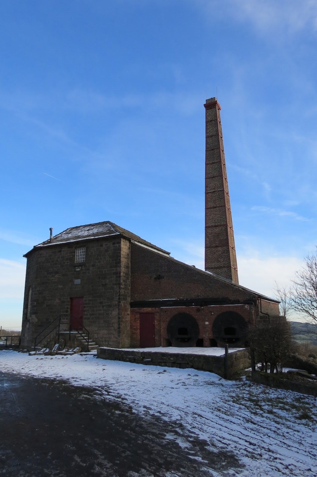
Next stop along the trail was Friden Brickworks, an industrial site that you might not think of as being particularly interesting.
However, the original business was founded in 1892 as the Derbyshire Silica Firebrick Company, Friden's location next to the railway line being an ideal one, and its longevity makes it a significant part of local history. The company has changed hands and changed name now but it is still one of the area's biggest employers and, apparently, still flourishing.
There's no escaping the fact that the appearance of the factory is a bit grim when its buildings first come into your line of sight but information boards and friezes decorate the factory wall that runs alongside the trail, which I thought was a nice touch, and there's an article on the brickworks in Derbyshire Life that makes for more interesting reading than you might imagine - unless you really like bricks, in which case you've probably clicked through to the article and aren't even reading the end of this overlong sentence.


Just beyond the factory is a public car park and picnic tables. It was almost eleven o'clock now and I suddenly realised that I'd been walking for around 4 hours with nothing other than the occasional swig of water or pause to take photos. I sat here for a while and had a rest, chatting to a cyclist who'd stopped at the next table.
Putting off lunch until the next picnic spot a couple of miles away near Gotham, I carried on along the trail, through more gently rolling farmland. The snow was noticeably thinner now I was further south into the county and many of the hillsides were bright green in the brilliant sunshine. My next target, Minninglow was in clear sight after leaving Friden behind, although it never seemed to get any closer no matter how much I walked.
Minninglow
Once I'd polished off half of my lunch, I began the final stretch to Minninglow. There's a huge, dual-pitched embankment here, in two sections - the first just after Gotham and the second immediately below Minninglow itself. In places it rises to around 50 feet high, topped with dry stone walling. Considering it was built in the 1820s, it's a very impressive and handsome work of engineering that deservedly has Grade II listed status.


Minninglow is an instantly recognisable sight in Derbyshire, its double crown of trees visible from all directions and from miles away. When we first saw it on the horizon from the Dark Peak last year we assumed it was a large building due to the outline of the trees on top; it was only when we zoomed in on a photo at home that we worked out what it was.
The hilltop is around 140 feet above the High Peak Trail and, like Arbor Low, on private land. Happily, at time of writing, there's a concessionary, signposted path to the summit, which contains several types of funereal earthworks dating from both the Neolithic and Bronze Ages within its walled enclosure. There's also archaeological evidence of activity there during the Roman occupation.


Back on the trail
Back down from this ancient site, I carried on along the trail. Just below the eastern side of the embankment as you leave Minninglow behind is an old field kiln in excellent condition, a leftover from when limestone quarrying and processing would've taken place in the immediate vicinity. These kilns were built close to the quarrying, their construction an easier option than moving the rock over extended distances.
The trail had become a little busier as the day wore on, which was natural enough because I was now passing through more access points as I went along. Even so, it was only the occasional cyclist or dog walker that I encountered so most of the time my view was still something along these lines, and the solitude was lovely.

A mile or so after Minninglow, the trail brought me to the hamlet of Longcliffe. A small collection of buildings gathered around a crossroads. Its economy seems mainly based around quarrying.
The trail runs above Longcliffe but back in the day this tiny settlement had a station on the railway and was a stopping point for the engines to take on water. Because of the dry and porous nature of limestone country, the water had to be shipped up here in massive tanks (or "tenders"), which were then drawn up onto a ramp to sit above incoming steam engines.
In fact, the difficulty of supplying a canal network with water on limestone uplands was a major contributing factor in the origins of the Cromford and High Peak Railway itself.
Leaving Longcliffe behind, the trail curved around through more cuttings and took in a pair of large, excitably barking dogs who announced their presence before I could actually see them. They were standing in the middle of the path and there was really no option but to pass them as there was a dearth of public footpaths in the neighbouring fields. Taking comfort from the fact that they were wagging their tails as furiously as they were barking, I walked purposefully past and - rather unnervingly - they suddenly stopped their racket and watched in silence as I did so.
Harboro Rocks
The next port of call was Harboro Rocks, an isolated ridge of exposed dolomite above the village of Brassington. The ridge is access land and there was a tumbled down section of wall that enabled me to get onto it. I'd been looking forward to exploring this prominence all day as it seemed from the map to offer a fantastic vantage point on the surrounding countryside. And I have to admit I was also getting a little bored of walking on such tame terrain for hours on end.

It didn't take long to climb to the top and I savoured the clamber up steep slopes and over rock. I wasn't disappointed with the views either, a green sea of hills to the east and west, Carsington Water a mere mile away to the south and on the horizon to the north, the uplands of the Dark Peak - looking considerably whiter than the White Peak today in their winter mantle.


I finished the remainder of my sandwiches and tea here, exhilarated by the scenery as much as by the keen wind.
I was enjoying the High Peak Trail - packed full of history both ancient and modern as it is - but it was nice to feel like I was somewhere a little bit wilder, if only for a moment. That said, the "wilderness" feeling did rather depend on which direction you were facing at the time, with enormous great wind turbines calmly rotating to the south and the concrete remains of old mining works on the slopes I'd climbed up. Sometimes, I suppose, you have to take what you can get and let the imagination fill in the rest!
After soaking it all in, I made my way to the southern end of the ridge where a public ROW takes you back down to the trail. I took my time, admiring the rock formations as I descended, and nearly went arse-over-elbow on a very muddy section of path near the bottom. The irony of doing this after spending seven hours walking on snow and ice without mishap didn't escape me.


Although I'd had a break for refreshments here I was still beginning to flag a little, I have to admit - probably like any of you still reading at this point. Around eighteen miles is the furthest I've walked in a day and I was approaching that mark now with some distance still to go.
The Inclines
Not long after Harboro Rocks I came to a little station house at Hopton Top and, beyond that, Hopton Incline. This was the first of several significant inclines between this point and the trail's end in Cromford and I was grateful to be walking it north-to-south. Originally, a stationary engine winched the trains up this steep section but when new owners took over in 1877 the winding engine was removed and the trains literally had to climb it under their own steam. Sometimes it took several attempts.


With the sun in my face all the time, it was easy to forget how cold it had been when I'd set out in earlier in the day but whenever I reached a tunnel or railway cuttings, I would be abruptly plunged back into winter conditions.


A mile or so later, I arrived at Middleton Top, probably the best preserved location on the old railway line in terms of industrial history. There's a visitor centre here (only open at weekends between November and Easter) and it's a popular spot to visit in itself, regardless of the trail that passes through it. Most impressive is the Engine House, which has been restored to working order, including the beam engine that used steam power to haul locomotives up Middleton Incline. For a small admission fee, the engine can be viewed in operation (without trains, of course) on certain days of the year. It's listed as a "monument of national importance".


I made my way gingerly down the steep incline, the trail having held onto its compacted snow cover even while the surroundings had thawed. I was approaching Cromford now and on this broad section of the trail, lined with woodland and expanses of grass, it felt more like I was wandering through a municipal park. There were a fair few people strolling around and walking their dogs here too, which added to the impression. There were still signs of the area's heritage though, such as the remains of the pit at the base of the incline where the steel cables used on the incline looped round a wooden wheel.
Further along, I passed Steeplehouse Station. This was once part of a branch line that accessed several quarries and the last revenue-earning part of the Cromford and High Peak Railway when it closed in 1967. Steeple Grange Light Railway is now run as a heritage railway, with plans for extension of the line being considered.

I could see Cromford in the valley below and, beyond it, Matlock too was visible through the steep sides of the valley carved out by the River Derwent. My plan was to walk along Cromford Canal and then into Matlock Bath. Once a spa resort, its main thoroughfare is now crowded with amusement arcades and chip shops, making for a curiously seaside-like tourist spot, popular with bikers. It was a sobering moment seeing how far below me the valley floor still was.

It was the final incline, from Sheep Pasture Top that was to bring me down to the end of the trail on the Derwent Valley floor. I say "bring me down" as though I travelled effortlessly by escalator but it was a long, long (1320 yards) walk down a very steep track that was done through gritted teeth and with continually protesting knees. Near the bottom, I passed the catch-pit, designed to catch runaway wagons and prevent the devastation they'd cause if they crashed into the workshops at High Peak Junction.
Finally, I arrived at High Peak Junction, officially the end of the High Peak Trail and the end of this blog.
It wasn't, however, the end of my walk as I still had a two-mile stretch along the canal and A6 into Matlock Bath. The canal walk itself became increasingly attractive as I went along but I didn't take any more photos after reaching High Peak Junction. To be honest, with aches on my aches and joints creaking like the front door of a haunted house, I'd practically given up the will to live at this point. All I could focus on was arriving in Matlock Bath in time to fit in a portion of chips and a can of pop before the chilly wait at the stop for my bus home. (And I'm happy to say, I achieved both of those objectives!)
All that said, it was a fantastic walk and - without the diversions I made - a relatively easy one, although of course still quite long. There's more industrial heritage on the southern half of the trail if that's of interest to you but it's worth remembering the inclines which add steep climbs if walking south-to-north. The route card from OS Maps shows how dramatic the height gain/loss is at these points.

Date: February 2018
Having walked on similar trails before, I was aware that long stretches can become somewhat routine, especially when they've been lined with bushes and trees or pass through extended railway cuttings. I decided to save this day out for winter, on the basis that a dusting of snow would lend some visual interest to even the most mundane of surroundings, and I also added on a few diversions from the trail - my feet certainly felt the effect of this by the end but each one was well worth the extra effort and mileage.

I was dropped off at the start of the trail at 7am, just outside Pomeroy, where the temperature was a balmy six degrees below zero and cloudless skies were beginning to hint at daybreak. It's an odd, hanging-in-the-air start (or end) point for such a significant trail - it would, of course, make sense for it to carry on to Buxton but there's still a small section of working railway line used by Dowlow Quarry here which blocks the connection with the town.

The chatter of tits in the bare trees beside the path kept me company, although it wasn't always easy to see them clearly in the tangle of twigs. There were other bird calls too, that I wasn't familiar with, and occasionally I managed to spot who was responsible, such as the female chaffinch pictured here.
On one side of me the sun was still hidden over the horizon, while on the other, the moon lingered in the sky, as though reluctant to acknowledge that the days were once again lengthening. The countryside undulates fairly gently around this northern section of the trail but the tops of the modest hills gradually began to shine as the sunlight reached them.


Eventually, passing under a bridge and rounding a bend, I too found myself the beneficiary of those surprisingly warm rays and had to fumble in my camera bag for the dusty, fingerprint-smudged sunglasses that had been stuffed in there unused since goodness knows when.


About an hour and a half into the walk, I arrived at the first noteworthy way point, Parsley Hay. There's a cafe, visitor centre and cycle hire shop here, though nothing is open during the winter. This spot was once a busy station and junction between the Cromford & High Peak Railway and the Ashbourne-Buxton line run by the London & North Western Railway. That line now forms the Tissington Trail and splits off from the High Peak Trail just south of Parsley Hay.
There was a lovely dry stone shelter here too, very snug inside, that turned out to be a traditional Istrian structure, built as a gift to the Peak District and the UK by Croatia on its accession to the European Union. It was constructed by Istrian masons using stone from local quarries.


Arbor Low and Gib Hill Barrow
 |
| Making my way to Arbor Low. |
This famous Neolithic henge and stone circle lies just over a mile away from Parsley Hay and has survived the four thousand years since it was constructed in remarkably fine condition. It consists of an extensive series of earth ramparts and ditches that enclose a ring of stones on a flattened mound at the site's north eastern end.
I struggled to get decent pictures of Arbor Low, hampered by the strong sunlight and the simple fact that I couldn't get high enough to give a good impression of the stones' layout. There are plenty of aerial photos online, though, that reveal how impressive it is. It's no surprise that it was one of the country's first scheduled monuments, being designated in 1882.
 |
| One of the entrances to the henge. |
 |
| The stone circle. |
Even before the henge was built, this ridge was an important location for religious ceremonies for the people who lived around this area. Gib Hill Barrow stands just under 300 yards away and its original structure pre-dates that of Arbor Low, although another barrow was later added to the original, early Neolithic tumulus during the Bronze Age.
 |
| Gib Hill Barrow. |
 |
| Arbor Low from Gib Hill. |
I had both these sites to myself and I didn't even see anyone when I passed through the farm that owns this land, leaving my £1 entrance fee in the honesty box by the gate. There were extensive views all around, making the location's significance to those ancient people understandable, and the sense of antiquity made the visit an atmospheric and quite humbling one.
Back on the trail
It took around an hour to get over to Arbor Low, look around and get back to the High Peak Trail. Just outside Parsley Hay, the path forked - my journey lay to the left and the Tissington Trail lay to the right, disappearing through a vast railway cutting.


It didn't take long for me to find myself in a deep cutting too and then approaching a tunnel under the A515. Unlike the smaller bridges I'd passed under earlier, the roof of this tunnel was covered in icicles. Some of them were quite large and, although most seemed to have formed nearer the tunnel sides, others were suspended like the Sword of Damocles directly overhead. Trying to ignore the niggling question of how much it'd hurt to be impaled by a falling shard of ice, I bravely stopped to take a few pictures of what was undeniably an impressive display.


The High Peak Trail makes for very easy walking along most of its course and I made good time here. Again my only companions were the birds in the trees dotted alongside the path, including my first sighting of a fieldfare, the middle picture below.


The trail was running along the top of an embankment at this point, not an especially high one but enough elevation to raise the path above the surrounding fields and open up the views. It really was perfect weather for a winter walk and while the scenery might not have been terribly dramatic, it was very lovely.


Friden Brickworks
 |
| Friden Brickworks. |
However, the original business was founded in 1892 as the Derbyshire Silica Firebrick Company, Friden's location next to the railway line being an ideal one, and its longevity makes it a significant part of local history. The company has changed hands and changed name now but it is still one of the area's biggest employers and, apparently, still flourishing.
There's no escaping the fact that the appearance of the factory is a bit grim when its buildings first come into your line of sight but information boards and friezes decorate the factory wall that runs alongside the trail, which I thought was a nice touch, and there's an article on the brickworks in Derbyshire Life that makes for more interesting reading than you might imagine - unless you really like bricks, in which case you've probably clicked through to the article and aren't even reading the end of this overlong sentence.


Just beyond the factory is a public car park and picnic tables. It was almost eleven o'clock now and I suddenly realised that I'd been walking for around 4 hours with nothing other than the occasional swig of water or pause to take photos. I sat here for a while and had a rest, chatting to a cyclist who'd stopped at the next table.
Putting off lunch until the next picnic spot a couple of miles away near Gotham, I carried on along the trail, through more gently rolling farmland. The snow was noticeably thinner now I was further south into the county and many of the hillsides were bright green in the brilliant sunshine. My next target, Minninglow was in clear sight after leaving Friden behind, although it never seemed to get any closer no matter how much I walked.
 |
| The snow thinned out the further south I got. |
 |
| Minninglow in the distance. |
Minninglow
Once I'd polished off half of my lunch, I began the final stretch to Minninglow. There's a huge, dual-pitched embankment here, in two sections - the first just after Gotham and the second immediately below Minninglow itself. In places it rises to around 50 feet high, topped with dry stone walling. Considering it was built in the 1820s, it's a very impressive and handsome work of engineering that deservedly has Grade II listed status.


 |
| Climbing up to Minninglow. |
The hilltop is around 140 feet above the High Peak Trail and, like Arbor Low, on private land. Happily, at time of writing, there's a concessionary, signposted path to the summit, which contains several types of funereal earthworks dating from both the Neolithic and Bronze Ages within its walled enclosure. There's also archaeological evidence of activity there during the Roman occupation.


Back on the trail
Back down from this ancient site, I carried on along the trail. Just below the eastern side of the embankment as you leave Minninglow behind is an old field kiln in excellent condition, a leftover from when limestone quarrying and processing would've taken place in the immediate vicinity. These kilns were built close to the quarrying, their construction an easier option than moving the rock over extended distances.
 |
| The remains of a field kiln below Minninglow. |

 |
| Ramp at Longcliffe station. |
The trail runs above Longcliffe but back in the day this tiny settlement had a station on the railway and was a stopping point for the engines to take on water. Because of the dry and porous nature of limestone country, the water had to be shipped up here in massive tanks (or "tenders"), which were then drawn up onto a ramp to sit above incoming steam engines.
 |
| Tenders on the ramp. |
Leaving Longcliffe behind, the trail curved around through more cuttings and took in a pair of large, excitably barking dogs who announced their presence before I could actually see them. They were standing in the middle of the path and there was really no option but to pass them as there was a dearth of public footpaths in the neighbouring fields. Taking comfort from the fact that they were wagging their tails as furiously as they were barking, I walked purposefully past and - rather unnervingly - they suddenly stopped their racket and watched in silence as I did so.
Harboro Rocks
The next port of call was Harboro Rocks, an isolated ridge of exposed dolomite above the village of Brassington. The ridge is access land and there was a tumbled down section of wall that enabled me to get onto it. I'd been looking forward to exploring this prominence all day as it seemed from the map to offer a fantastic vantage point on the surrounding countryside. And I have to admit I was also getting a little bored of walking on such tame terrain for hours on end.

It didn't take long to climb to the top and I savoured the clamber up steep slopes and over rock. I wasn't disappointed with the views either, a green sea of hills to the east and west, Carsington Water a mere mile away to the south and on the horizon to the north, the uplands of the Dark Peak - looking considerably whiter than the White Peak today in their winter mantle.


 |
| Not quite an unspoiled wilderness... |
I was enjoying the High Peak Trail - packed full of history both ancient and modern as it is - but it was nice to feel like I was somewhere a little bit wilder, if only for a moment. That said, the "wilderness" feeling did rather depend on which direction you were facing at the time, with enormous great wind turbines calmly rotating to the south and the concrete remains of old mining works on the slopes I'd climbed up. Sometimes, I suppose, you have to take what you can get and let the imagination fill in the rest!
After soaking it all in, I made my way to the southern end of the ridge where a public ROW takes you back down to the trail. I took my time, admiring the rock formations as I descended, and nearly went arse-over-elbow on a very muddy section of path near the bottom. The irony of doing this after spending seven hours walking on snow and ice without mishap didn't escape me.


Although I'd had a break for refreshments here I was still beginning to flag a little, I have to admit - probably like any of you still reading at this point. Around eighteen miles is the furthest I've walked in a day and I was approaching that mark now with some distance still to go.
The Inclines
Not long after Harboro Rocks I came to a little station house at Hopton Top and, beyond that, Hopton Incline. This was the first of several significant inclines between this point and the trail's end in Cromford and I was grateful to be walking it north-to-south. Originally, a stationary engine winched the trains up this steep section but when new owners took over in 1877 the winding engine was removed and the trains literally had to climb it under their own steam. Sometimes it took several attempts.


With the sun in my face all the time, it was easy to forget how cold it had been when I'd set out in earlier in the day but whenever I reached a tunnel or railway cuttings, I would be abruptly plunged back into winter conditions.


A mile or so later, I arrived at Middleton Top, probably the best preserved location on the old railway line in terms of industrial history. There's a visitor centre here (only open at weekends between November and Easter) and it's a popular spot to visit in itself, regardless of the trail that passes through it. Most impressive is the Engine House, which has been restored to working order, including the beam engine that used steam power to haul locomotives up Middleton Incline. For a small admission fee, the engine can be viewed in operation (without trains, of course) on certain days of the year. It's listed as a "monument of national importance".


I made my way gingerly down the steep incline, the trail having held onto its compacted snow cover even while the surroundings had thawed. I was approaching Cromford now and on this broad section of the trail, lined with woodland and expanses of grass, it felt more like I was wandering through a municipal park. There were a fair few people strolling around and walking their dogs here too, which added to the impression. There were still signs of the area's heritage though, such as the remains of the pit at the base of the incline where the steel cables used on the incline looped round a wooden wheel.
 |
| The wheel pit. |

I could see Cromford in the valley below and, beyond it, Matlock too was visible through the steep sides of the valley carved out by the River Derwent. My plan was to walk along Cromford Canal and then into Matlock Bath. Once a spa resort, its main thoroughfare is now crowded with amusement arcades and chip shops, making for a curiously seaside-like tourist spot, popular with bikers. It was a sobering moment seeing how far below me the valley floor still was.

It was the final incline, from Sheep Pasture Top that was to bring me down to the end of the trail on the Derwent Valley floor. I say "bring me down" as though I travelled effortlessly by escalator but it was a long, long (1320 yards) walk down a very steep track that was done through gritted teeth and with continually protesting knees. Near the bottom, I passed the catch-pit, designed to catch runaway wagons and prevent the devastation they'd cause if they crashed into the workshops at High Peak Junction.
 |
| Engine house at the top of Sheep Pasture Incline. |
 |
| The accident that prompted the construction of a catch-pit. |
 |
| The catch-pit today. |
 |
| At High Peak Junction |
It wasn't, however, the end of my walk as I still had a two-mile stretch along the canal and A6 into Matlock Bath. The canal walk itself became increasingly attractive as I went along but I didn't take any more photos after reaching High Peak Junction. To be honest, with aches on my aches and joints creaking like the front door of a haunted house, I'd practically given up the will to live at this point. All I could focus on was arriving in Matlock Bath in time to fit in a portion of chips and a can of pop before the chilly wait at the stop for my bus home. (And I'm happy to say, I achieved both of those objectives!)
All that said, it was a fantastic walk and - without the diversions I made - a relatively easy one, although of course still quite long. There's more industrial heritage on the southern half of the trail if that's of interest to you but it's worth remembering the inclines which add steep climbs if walking south-to-north. The route card from OS Maps shows how dramatic the height gain/loss is at these points.

Date: February 2018
Walk length: 38.5 km
Total ascent: 536 metres


I'm in awe of your length of walk! Wow... especially on a winter's day with limited daylight! What a gorgeous day you had for the walk though. I'm planning on walking the Sandstone Trail this summer, but I'll be doing it in 3 sections so about 12/13 miles in a day. Think that'd be my limit on distance, lol...
ReplyDeleteOh, and the irony surrounding your near fall. Immediately reminded me of the time I ran down the full grassy height of Shutlingsloe (the steep way) in a race with my cousin's, just to fall on the hard gravel at the bottom splitting open my knees and elbows! I've always been super cautious coming downhill ever since!
This is the first post I've come across on your blog, and I'll certainly be checking out more if your walks!
Thanks, Tilly. It was a long walk but I made the most of the daylight by starting around 7am and you can't really get lost on the trail even in the dark. I've been looking at the Sandstone Trail too for sometime this year, maybe over two days to minimise the cost of accommodation. If you get to do it first, I'd love to hear how you found it. All the best, Justin.
Delete