The Dark Peak is justly famous for its heather and peat-blanketed uplands and the dark gritstone edges, scoured by centuries of wind and rain, that gaze menacingly down on its vast reservoirs - this is many people's first image when someone says they're going walking in the Peak District and it's probably usually mine too. It's not the whole story though, as picturesque towns like Bakewell and Matlock bear witness, and the fertile farmland in which they lie contains some real hidden gems for the hiker.
We ventured back into this territory late last year, when we had a friend staying with us who was temporarily using a wheelchair. A search for accessible outdoor locations led us to Tideswell Dale and we made a note to return and explore the area further.
That short outing brought us, albeit much later than we planned, to Cressbrook Dale last month. We left the car at a free roadside parking spot by the River Wye on the lane between Monsal Head and Cressbrook village.
From here we strolled in the direction of Cressbrook, with pasture land and the river on one side and the steep hillside on the other. At this stage of the walk we just skirted the southern end of the village, where there was evidence of its industrial past. The impressive-looking Cressbrook Mill - now apartments - lay to our left and a small reservoir, presumably to service the mill back in the day, lay through a gate in the wall on our left.
Our path was to take us up the lane on the right, away from the centre of the village and following the side of the reservoir and the stream that ran into it.
The old stone buildings and walls of the village proper that we could see as we headed past spoke of an ancient community that had been part of the landscape for centuries. In fact the bulk of Cressbrook village is (in historical terms at least) a relatively recent settlement, that only came into existence around the 1760s. The larger part of dwellings that are there now were built during the heyday of the mills in the 19th century, though there are some older cottages that testify to people living and working in the area on a small scale prior to the Industrial Revolution.
As we progressed along the lane into the dale, there were glimpses through the trees of how dramatic the landscape was becoming around and above us. On the the dale's eastern edge, a line of crags were showing through the trees high above us. These were revealed in all their rugged grandeur when we reached the delightful Ravensdale Cottages at the base of the cliffs (this is their name according to the OS map, but they're also sometimes referred to as Cressbrook Cottages). The crags above are the site of Ravencliffe Cave, in which evidence of habitation from the Upper Palaeolithic and Neolithic eras has been found. Apparently the cave is accessible via a concessionary path behind the cottages.
There had been wild garlic growing at the side of the lane as we passed the edge of the village but down here in the wooded section of the dale it stretched out between the trees as far as the eye could see and the air was steeped in its aroma. It made me feel quite hungry, though the cheese butties in my backpack now seemed quite uninspired next to the culinary images the flowers' scent was conjuring up in my mind.
Eventually both the trees - and the aromatic garlic - began to thin out. The path skirted the right hand side of the gorge and to our left was a damp riverbed. We were doing the walk at the end of a prolonged dry spell and the water course here was simply a broad ribbon of mud and rocks. There was a more active stream, now behind us by Ravensdale Cottages, that fed ultimately into the mill reservoir in Cressbrook and we surmised that perhaps that this tributary, running through the dale ahead of us, disappeared underground apart from in the most rain-soaked conditions.
Soon, the dale began to expand before us. It was a majestic sight with its limestone outcrops towering above, particularly after being in the warm, sheltered confines of the wood. There didn't seem to be anything in the way of a stream in the open dale either, save a small expanse of wet and marshy ground that gradually petered out as we walked onwards - perhaps this was the source of the brook, a spring welling up from the limestone below the soil to form a bourne?
Cressbrook Dale forms part of the Derbyshire Dales National Nature Reserve, several physically unconnected dales in this area of the White Peak, notable for their distinctive flora and fauna. Cressbrook Dale is famous for the early purple orchid and our walk was timed perfectly to coincide with its appearance. They were a glorious sight.
By this time another of Cressbrook Dale's natural wonders had come into view, one that I was keen to explore. This was Peter's Stone, a striking limestone outcrop that - I discovered - looked radically different in form depending on your viewpoint; only when we reached the far end of the dale and looked back did its dome-shape become clear.
Also known as Gibbet Rock, this was apparently the site of the county's last gibbet. The last gibbeting was that of a youth from nearby Tideswell, who had robbed and murdered a toll-keeper in the nearby hamlet of Wardlow Mires for her red boots. The sorry tale is elaborated on here. As far as I could see, however, there were no indications that a gibbet had once stood here so I presume it was entirely constructed of perishable material such as wood.
Peter's Stone was up a fairly steep slope and, after some deliberation, Rich decided to wait down below with Lotte. The rock itself was certainly no sort of terrain for a dog even if we had been able to get her up to the crown of the outcrop.
From below, where I began my climb up the hillside, it looked quite broad but once I got to the right hand edge (in the picture below) it proved to be relatively narrow, forming a long ridge. There were fissures all around its sides that offered potential routes to the top and, indeed, much of the summit itself was criss-crossed by karst rifts. It was as if a section of limestone pavement had been pushed into the air by a giant hand from below.
There were some excellent views along the dale in both directions from the top and I've included one of Rich and Lotte down below to give a sense of scale to the photographs.
I found another fissure further along the ridge that provided a less precarious exit than those on the more exposed front of the rock and headed downhill to a series of smaller, companion outcrops. I'd passed these, on my left, as I climbed up the slope. They don't appear to have a name, that I can find at least, but they are still quite imposing in their own way. And they too offered fine views of the rest of the dale that lay ahead of us.
We were nearly at the end of the dale now and it really was a stunning place. We weren't surprised at the number of walkers and professional photographers, with tripods and extravagant zoom-lenses, that we passed.
It was towards the north-east end of the dale that we came across a cave mouth, which Lotte was more eager to investigate than we were. It appears that lead mining once took place in the dale and the man-made tunnels interconnect with the natural caves running through the limestone. There is an entrance to the old Neptune Mine somewhere in the vicinity too but we didn't see it on our travels.
We returned to the modern world at the A623 by Somerset House Farm but rather than follow what appeared to be quite a busy road, we turned sharply and headed south-west along the public footpath that crossed the pastures above Cressbrook Dale. Here I was treated to one of my favourite sights in the spring, a buttercup meadow, though this section of the walk also afforded us some spectacular vistas of the valley from above.
Our route was to take us across these meadows to Mires Lane and, from there into the village of Litton. When we appeared in the lane, a group of young-looking cattle across the road made a beeline for the wall and followed Rich and Lotte as they walked along the verge.
Litton proved to be a charming village, made up of mostly small properties with neat and well-tended gardens. These were cottages that had been occupied by the lead miners back in the day. Gleaming in the bright spring sunshine, it seemed a quintessentially English and welcoming sight.
Unfortunately, we still had a fair walk ahead of us, tempting though the village pub looked. Our path lay out of the village, south and then south-east, across farmland to the ridge above the wooded section of Cressbrook Dale. Cows were scattered across some of the pasture to our left and right as we headed out of the village but we were relieved to see that the clearly delineated track ahead of us lay across empty fields.
When plotting our walk, the footpath along the western ridge of Cressbrook Dale had looked like it would offer dramatic views down onto our route earlier in the day but as it turned out, the sides and bottom of the dale were thick with trees. There was little else to see aside from their trunks, rendering this section a pleasant but unremarkable woodland walk. Even the wild garlic that swathed the dale floor in such abundance was nowhere to be seen - or smelled - this high up.
We did at one point get a brief glimpse of the crags, now at eye-level, on the rough-hewn eastern side of the dale. Most of the walk at this point however was spent either trying to swat the swarms of gnats that had suddenly appeared from nowhere, or concentrating on carefully navigating the sometimes very narrow path. There were trees a-plenty below that would surely break a fall before very long but the bank was steep indeed and I had no desire to hug a tree at high speed or upside down.
Soon we descended from the wooded path and re-entered Cressbrook village, emerging from behind some houses. From here we took a right turn and headed roughly west along the lane, passing the village's memorial to the two World Wars.
We were now above Millers Dale, site of another reminder of the area's industrialised past. The huge mill building now contains apartments, like Cressbrook Mill further down the river, and the spectacular gorge in which it sits must make for stunning views from its windows, whatever the season.
A couple of centuries back, though, the secluded Litton Mill was the scene of horrific mistreatment of child workers over several decades and the ensuing scandal when this was publicised informed the passing of the 1833 Factory Act. You can read here some sobering testimony from one Robert Blincoe, who had worked at the mill as a child, when he was interviewed by the factory inspectors as part of the government-led investigation.
Not far out of Cressbrook we left the lane and began to follow a track across a field. This eventually took a steep turn as it led us down into the Millers Dale. We could see from here the sharp bend in the river known as Water-cum-Jolly Dale and, cutting across the hillside above it to the right, the straight line of the Monsal Trail, once the route of the Midland Railway line.
When we arrived at the River Wye, we got our first proper view of the mill and the hamlet that nestles by its side on the riverbank.
It was an idyllic scene, one far removed from the noise, smells and pollution that must have blighted the gorge at the height of the mill's working life. And, indeed, afterwards - I was surprised to learn how busy the old Midland Railway line was into the twentieth century and the Miller's Dale station in particular seems to have been an important hub.
We were to cross the river here and climb up a steep slope to join the Monsal Trail. Where once trains thundered along, now the walker is accompanied by birdsong and the occasional whir of cyclists as they pass by on the eight-and-a-half mile route from Bakewell to Chee Dale.
The views from up here were even more gratifying than those from the far side of the dale, where we'd descended: we got more of a sense of on how grand a scale the mill complex had been built. Further along to the east, the trail looked down into Water-cum-Jolly Dale and it was easy to see why so many rock climbers are drawn to the area.
Picturesque though views around the trail are, there are reminders that this was once the domain of the locomotive - bridges, tunnels through the hillside and even the remains of a platform at one point. The tunnels, though, were the most impressive and atmospheric reminders of the past and it's great that they're all open to the walker and cyclist now. Hikers would have to follow footpaths on the hillside around them prior to their reopening but now they are well lit and the ground has been relaid underfoot. The walls and tunnel roofs are still caked in the soot and other by-products of the trains, however, and at every entrance there is a sign warning passer-through not to touch their surfaces.
We were on the last section of our walk now - from Litton Mill to Monsal Head is around a mile and three quarters - and I'd planned the route to end on what I hoped would be a high note (leaving aside the pub that marked the proper end of our day out). This was the 1863 Headstone Viaduct that crosses Monsal Dale - and this marvel of Victorian engineering didn't disappoint, either in the views it offered into Monsal Dale or in its own elegant but grandiose design.
Our diversion to the base of the viaduct was well worth it, even if it did involve a steep climb back up. There was a further steep climb to follow as we left the Monsal Trail at this point - next on our route was the all-important pint of bitter shandy and conveniently enough the Monsal Head Hotel was not only just above us but also at the head of the lane on which we'd parked.
It stands above a sharp bend in the Wye and from the lane there you get a great view of the viaduct and Monsal Dale in one direction and Upperdale (which becomes Water-cum-Jolly, then Millers Dale) in the other.
It was a fitting viewpoint to end what was one of the most varied walks we've been on, rich in natural and industrial history and with some of the most stunning scenery. I feel as though we barely scratched the surface of what these dales have to offer, even though we did spend a full day wandering, and the area is high on the list for return visits.
Date: May 2015
Walk length: 13.5 km
Total ascent: 624 metres
We ventured back into this territory late last year, when we had a friend staying with us who was temporarily using a wheelchair. A search for accessible outdoor locations led us to Tideswell Dale and we made a note to return and explore the area further.
That short outing brought us, albeit much later than we planned, to Cressbrook Dale last month. We left the car at a free roadside parking spot by the River Wye on the lane between Monsal Head and Cressbrook village.
From here we strolled in the direction of Cressbrook, with pasture land and the river on one side and the steep hillside on the other. At this stage of the walk we just skirted the southern end of the village, where there was evidence of its industrial past. The impressive-looking Cressbrook Mill - now apartments - lay to our left and a small reservoir, presumably to service the mill back in the day, lay through a gate in the wall on our left.
 |
| Cressbrook Mill |
 |
| The reservoir by Cressbrook Mill |
 |
| The reservoir. |
The old stone buildings and walls of the village proper that we could see as we headed past spoke of an ancient community that had been part of the landscape for centuries. In fact the bulk of Cressbrook village is (in historical terms at least) a relatively recent settlement, that only came into existence around the 1760s. The larger part of dwellings that are there now were built during the heyday of the mills in the 19th century, though there are some older cottages that testify to people living and working in the area on a small scale prior to the Industrial Revolution.
As we progressed along the lane into the dale, there were glimpses through the trees of how dramatic the landscape was becoming around and above us. On the the dale's eastern edge, a line of crags were showing through the trees high above us. These were revealed in all their rugged grandeur when we reached the delightful Ravensdale Cottages at the base of the cliffs (this is their name according to the OS map, but they're also sometimes referred to as Cressbrook Cottages). The crags above are the site of Ravencliffe Cave, in which evidence of habitation from the Upper Palaeolithic and Neolithic eras has been found. Apparently the cave is accessible via a concessionary path behind the cottages.
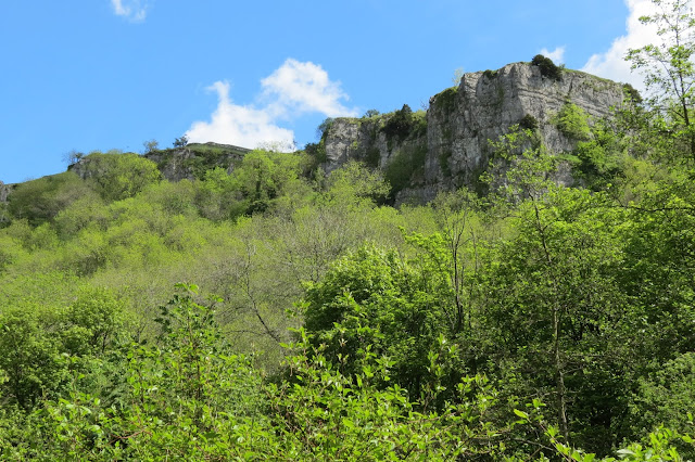 |
| The crags above Cressbrook Dale |
 |
| Ravensdale Cottages |
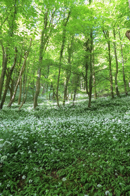
There had been wild garlic growing at the side of the lane as we passed the edge of the village but down here in the wooded section of the dale it stretched out between the trees as far as the eye could see and the air was steeped in its aroma. It made me feel quite hungry, though the cheese butties in my backpack now seemed quite uninspired next to the culinary images the flowers' scent was conjuring up in my mind.
 |
| Forget-me-nots below the gorge side |
Soon, the dale began to expand before us. It was a majestic sight with its limestone outcrops towering above, particularly after being in the warm, sheltered confines of the wood. There didn't seem to be anything in the way of a stream in the open dale either, save a small expanse of wet and marshy ground that gradually petered out as we walked onwards - perhaps this was the source of the brook, a spring welling up from the limestone below the soil to form a bourne?
 |
| The small patch of marshy ground we came across as the dale opened out. |
 |
| Looking down into the dale, with its exposed ridges of limestone. |
Cressbrook Dale forms part of the Derbyshire Dales National Nature Reserve, several physically unconnected dales in this area of the White Peak, notable for their distinctive flora and fauna. Cressbrook Dale is famous for the early purple orchid and our walk was timed perfectly to coincide with its appearance. They were a glorious sight.
 |
| A swathe of early purple orchids |
 |
| The early purple orchid. |
By this time another of Cressbrook Dale's natural wonders had come into view, one that I was keen to explore. This was Peter's Stone, a striking limestone outcrop that - I discovered - looked radically different in form depending on your viewpoint; only when we reached the far end of the dale and looked back did its dome-shape become clear.
 |
| Peter's Stone from the bottom of the dale. |
Peter's Stone was up a fairly steep slope and, after some deliberation, Rich decided to wait down below with Lotte. The rock itself was certainly no sort of terrain for a dog even if we had been able to get her up to the crown of the outcrop.
From below, where I began my climb up the hillside, it looked quite broad but once I got to the right hand edge (in the picture below) it proved to be relatively narrow, forming a long ridge. There were fissures all around its sides that offered potential routes to the top and, indeed, much of the summit itself was criss-crossed by karst rifts. It was as if a section of limestone pavement had been pushed into the air by a giant hand from below.
There were some excellent views along the dale in both directions from the top and I've included one of Rich and Lotte down below to give a sense of scale to the photographs.
 |
| Heading up a daisy-strewn path at the southern end of Peter's Stone |
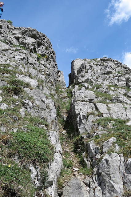 |
| My route up to the top. |
 |
| Looking north-east to the top of Cressbrook Dale |
 |
| Rich and Lotte back down in the dale. |
I found another fissure further along the ridge that provided a less precarious exit than those on the more exposed front of the rock and headed downhill to a series of smaller, companion outcrops. I'd passed these, on my left, as I climbed up the slope. They don't appear to have a name, that I can find at least, but they are still quite imposing in their own way. And they too offered fine views of the rest of the dale that lay ahead of us.
 |
| The companions to Peter's Stone. |
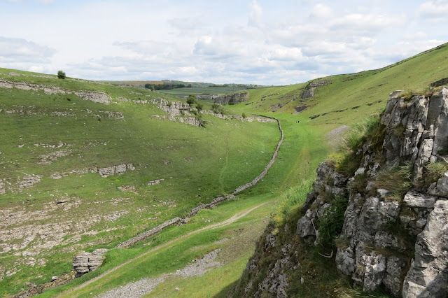 |
| Looking north-east along the dale. |
 |
| Lotte goes caving. |
It was towards the north-east end of the dale that we came across a cave mouth, which Lotte was more eager to investigate than we were. It appears that lead mining once took place in the dale and the man-made tunnels interconnect with the natural caves running through the limestone. There is an entrance to the old Neptune Mine somewhere in the vicinity too but we didn't see it on our travels.
We returned to the modern world at the A623 by Somerset House Farm but rather than follow what appeared to be quite a busy road, we turned sharply and headed south-west along the public footpath that crossed the pastures above Cressbrook Dale. Here I was treated to one of my favourite sights in the spring, a buttercup meadow, though this section of the walk also afforded us some spectacular vistas of the valley from above.
 |
| Crossing the buttercup meadow above Cressbrook Dale |
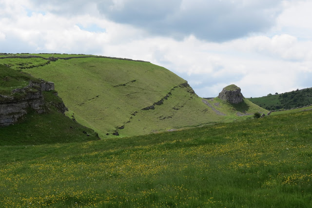 |
| The far side of Cressbrook Dale, with Peter's Stone. |
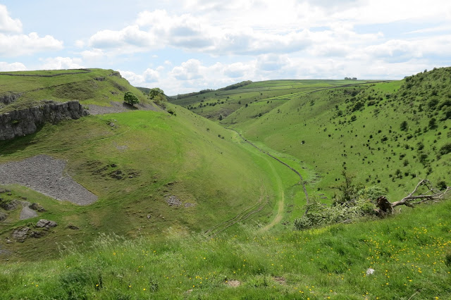 |
| Cressbrook Dale from above. |
Our route was to take us across these meadows to Mires Lane and, from there into the village of Litton. When we appeared in the lane, a group of young-looking cattle across the road made a beeline for the wall and followed Rich and Lotte as they walked along the verge.
 |
| Trying to get a closer look... |
 |
| A bank of forget-me-nots in Litton. |
Unfortunately, we still had a fair walk ahead of us, tempting though the village pub looked. Our path lay out of the village, south and then south-east, across farmland to the ridge above the wooded section of Cressbrook Dale. Cows were scattered across some of the pasture to our left and right as we headed out of the village but we were relieved to see that the clearly delineated track ahead of us lay across empty fields.
 |
| Following the clear footpath to the tree-lined ridge of Cressbrook Dale on the left. |
 |
| Dry stone walls in the farmland by Litton |
When plotting our walk, the footpath along the western ridge of Cressbrook Dale had looked like it would offer dramatic views down onto our route earlier in the day but as it turned out, the sides and bottom of the dale were thick with trees. There was little else to see aside from their trunks, rendering this section a pleasant but unremarkable woodland walk. Even the wild garlic that swathed the dale floor in such abundance was nowhere to be seen - or smelled - this high up.
We did at one point get a brief glimpse of the crags, now at eye-level, on the rough-hewn eastern side of the dale. Most of the walk at this point however was spent either trying to swat the swarms of gnats that had suddenly appeared from nowhere, or concentrating on carefully navigating the sometimes very narrow path. There were trees a-plenty below that would surely break a fall before very long but the bank was steep indeed and I had no desire to hug a tree at high speed or upside down.
 |
| Crags on the far side of the dale, with the conical profile of Wardlow Hay Cop above them to the left. |
Soon we descended from the wooded path and re-entered Cressbrook village, emerging from behind some houses. From here we took a right turn and headed roughly west along the lane, passing the village's memorial to the two World Wars.
We were now above Millers Dale, site of another reminder of the area's industrialised past. The huge mill building now contains apartments, like Cressbrook Mill further down the river, and the spectacular gorge in which it sits must make for stunning views from its windows, whatever the season.
A couple of centuries back, though, the secluded Litton Mill was the scene of horrific mistreatment of child workers over several decades and the ensuing scandal when this was publicised informed the passing of the 1833 Factory Act. You can read here some sobering testimony from one Robert Blincoe, who had worked at the mill as a child, when he was interviewed by the factory inspectors as part of the government-led investigation.
Not far out of Cressbrook we left the lane and began to follow a track across a field. This eventually took a steep turn as it led us down into the Millers Dale. We could see from here the sharp bend in the river known as Water-cum-Jolly Dale and, cutting across the hillside above it to the right, the straight line of the Monsal Trail, once the route of the Midland Railway line.
 |
| Water-cum-Jolly Dale and a short section of the Monsal Trail on hillside above it. |
 |
| Litton Mill appears below us in the dale. |
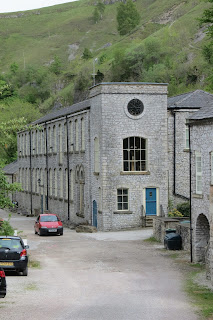 |
| Litton Mill |
It was an idyllic scene, one far removed from the noise, smells and pollution that must have blighted the gorge at the height of the mill's working life. And, indeed, afterwards - I was surprised to learn how busy the old Midland Railway line was into the twentieth century and the Miller's Dale station in particular seems to have been an important hub.
We were to cross the river here and climb up a steep slope to join the Monsal Trail. Where once trains thundered along, now the walker is accompanied by birdsong and the occasional whir of cyclists as they pass by on the eight-and-a-half mile route from Bakewell to Chee Dale.
The views from up here were even more gratifying than those from the far side of the dale, where we'd descended: we got more of a sense of on how grand a scale the mill complex had been built. Further along to the east, the trail looked down into Water-cum-Jolly Dale and it was easy to see why so many rock climbers are drawn to the area.
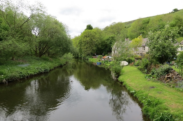 |
| Crossing the River Wye. |
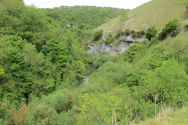 |
| Water-cum-Jolly Dale from the Monsal Trail. |
Picturesque though views around the trail are, there are reminders that this was once the domain of the locomotive - bridges, tunnels through the hillside and even the remains of a platform at one point. The tunnels, though, were the most impressive and atmospheric reminders of the past and it's great that they're all open to the walker and cyclist now. Hikers would have to follow footpaths on the hillside around them prior to their reopening but now they are well lit and the ground has been relaid underfoot. The walls and tunnel roofs are still caked in the soot and other by-products of the trains, however, and at every entrance there is a sign warning passer-through not to touch their surfaces.
 |
| One of the tunnels along the Monsal Trail. |
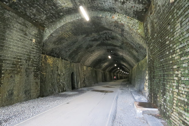 |
| Inside the Litton Tunnel. |
We were on the last section of our walk now - from Litton Mill to Monsal Head is around a mile and three quarters - and I'd planned the route to end on what I hoped would be a high note (leaving aside the pub that marked the proper end of our day out). This was the 1863 Headstone Viaduct that crosses Monsal Dale - and this marvel of Victorian engineering didn't disappoint, either in the views it offered into Monsal Dale or in its own elegant but grandiose design.
 |
| Looking into Monsal Dale from the top of the viaduct. |
 |
| The River Wye in Monsal Dale. |
 |
| Lotte and Rich in front of Headstone Viaduct. |
Our diversion to the base of the viaduct was well worth it, even if it did involve a steep climb back up. There was a further steep climb to follow as we left the Monsal Trail at this point - next on our route was the all-important pint of bitter shandy and conveniently enough the Monsal Head Hotel was not only just above us but also at the head of the lane on which we'd parked.
It stands above a sharp bend in the Wye and from the lane there you get a great view of the viaduct and Monsal Dale in one direction and Upperdale (which becomes Water-cum-Jolly, then Millers Dale) in the other.
 |
| Headstone Viaduct and Monsal Dale. |
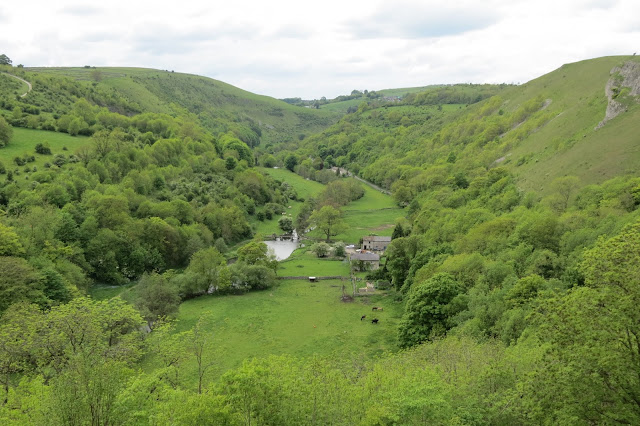 |
| Upperdale, with Water-cum-Jolly and Millers Dales beyond. |
It was a fitting viewpoint to end what was one of the most varied walks we've been on, rich in natural and industrial history and with some of the most stunning scenery. I feel as though we barely scratched the surface of what these dales have to offer, even though we did spend a full day wandering, and the area is high on the list for return visits.
Date: May 2015
Walk length: 13.5 km
Total ascent: 624 metres




0 comments:
Post a Comment